
This gallery contains 3 photos.
During our five day stay in Picton, we made plans thinking we would be without a car which did not turn out to be the case. We posted an ad when we got to Rarangi and received only one call … Continue reading

This gallery contains 3 photos.
During our five day stay in Picton, we made plans thinking we would be without a car which did not turn out to be the case. We posted an ad when we got to Rarangi and received only one call … Continue reading

This gallery contains 94 photos.
With our return to the US only a month away, it is inevitable that our thoughts are more and more focused on wrapping up this adventure and returning to our house in Colorado. At the same time this reality emphasizes … Continue reading

This gallery contains 60 photos.
When you look on a map the skinny little strip north of Auckland is where we are. Northland may look skinny on the map, but when you zoom in and look at it from behind the windshield it gets much … Continue reading
Our journey north to Ahipara took us through Auckland on a bright clear day. We managed to avoid any major traffic delays and sailed right on through the city. As we crossed the Harbour Bridge the sun was highlighting Auckland’s gorgeous city center marked by the sharp sky tower reaching from the sparkling waters of the bay to stab the blue sky.

Auckland skyline from Harbour Bridge
We stopped over for the night in Wellsford to break up the long drive to 90 mile beach. While checking in, we couldn’t help but notice a group of somewhat noisy youths who were also checking in for the night. We were glad to have slept through most of the drama during that single night and just hear the details from the owner in the morning as we prepared to leave. Apparently, one of the kids that was staying there with the group to attend a birthday party in town had been stabbed at the party and required transport to the hospital via helicopter from the hotel during the wee hours of the morning. We hoped to leave that sort of drama behind as we drove further up the North Island. About an hour into the trip, we stopped at the Kauri Museum in Matakohe, persuaded by the rave reviews on trip advisor and a plug from the hotel owner in Wellsford.

The Kauri Museum

Kauri plank. Note the bench at the far end, staircase and large dresser on back wall for perspective. The circles on the wall are the size of cross sections of the largest trees found.
We did have fair warning that it would take considerable time to navigate the entire museum. We also knew that it would be unlikely that we would be traveling through this area again so we decided to take the time to have a look. It was well worth it. The museum examined New Zealand history through the industries involving the kauri trees. The displays were interactive and informative and were intriguing enough to keep our attention despite the arctic temperatures in the buildings where they were housed.
My hands were numb after an hour, and I even had gloves on. When we couldn’t take any more of the cold, we stopped to go across the street and have an early lunch to warm up. Thankfully, when we returned to the museum, we realized the only remaining sections to look at were closer to the gift shop where it was warmer. My personal favorite, the kauri gum collection.
")
")
")

View from the museum carpark
Then it was back in the car. We chose to take a route through the Waipoua forest on our way up to Ahipara so we could also see the oldest and largest living kauri trees. Making these extra stops meant we’d be arriving in Ahipara after dark, but again we knew that our travel plans would not allow for a visit to the forest later. Late in the afternoon we pulled into the carpark at the first walk to see some giant ancient kauri trees, Te Matua Ngahere and the four sisters.

Deb gazing at “The Four Sisters”


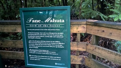
Clouds hung low and it was cool but not unpleasant for walking, especially since we’d increased our pace to make sure we saw them while it was still light. Only a short distance up the road we stopped again to walk to Tane Mahutu, also known as the “Lord of the Forest.” Standing at the base of this giant tree, it felt imperative that we pause and simply be still in its presence. To stare up as such a strong and magnificent presence was rather overwhelming and even more so when contemplating that it has been living for around 1500 years. I find that incomprehensible.

That’s my tiny silhouette by the fence
From there we had nearly three more hours on the road according to the GPS. I was in charge of searching the best route and found myself getting frustrated that the phone kept indicating that we needed to drive across the island to Hwy 1, it seemed really out of the way, when I could see roads on the map that provided a more direct route. As we kept driving, the map app shifted to reflect route I’d been seeing. Well, as we approached the next turn we got a surprise. There was a sign “Ahipara via ferry.” Upon reading this, it was clear why the GPS had originally indicated a different course. At that point we were faced with either continuing to the opposite coast and having to back track or driving to the ferry to see if we might be able to get on. We turned in and drove up to check the ferry schedule but we could see the ferry approaching the dock as we came over the hill and there were a handful of cars in line to get on so we pulled into the back of the line. We were laughing out loud, more in disbelief than because we found it actually funny. The timing was astonishing. We only had to wait about 15 minutes and we were on the boat crossing to pick up the road to 90 mile beach for the last hour of our journey.

On board the ferry
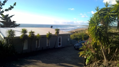
The curves kept coming, back and forth we followed. Our host told us of a good Thai place in Kaitaia that we unfortunately didn’t get to try since they were closed. Generally we avoid American fast food even in the US, and we’ve been even more reluctant here in New Zealand, but anxious to get to the house where we’d be staying, we scanned the street for options and landed on Subway. We walked just before they closed and were obviously the last customers of the evening. From Kaitaia we still had another fifteen minutes and based on the instructions from our host we were a little concerned about finding the house. We only had to turn around twice during the search but we did find it. The driveway was extraordinarily steep, both of us were somewhat nervous about driving down it wondering if we’d ever get the little rental car back out. The roar of the ocean greeted us as we stepped out of the car, and the soothing sound was only slightly dampened by the glass wall of the house once we went inside. Immediately, even in the dark, we knew that we would love staying here, whether we went exploring during the week or not.
View from the driveway

Breakfast overlooking 90 mile beach

View from the deck
We felt fortunate to have found this house available. It was designed to perfectly soak up the surroundings. It was easy to find a comfortable spot to listen and absorb the tranquility so we weren’t in any hurry to leave to go find anywhere else to be. It suited us perfectly for the week.

View of 90 mile beach from the deck
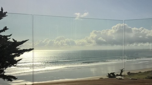
View through deck railing
One destination we wanted to check out was Cape Reinga on the very far north tip of the country. We booked a tour so Paul could simply enjoy the trip as a passenger and not have to drive. After a short shuttle ride to pick up the tour bus, we boarded the 4wd “Dune Rider” bus which took us up Hwy 1 to Cape Reinga. The first stop was at Gumdiggers park for a look around at the buried kauri forest. What a fascinating stop it was! I was just as fascinated with the dew covered spider webs as the buried forest.
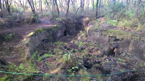
Giant buried kauri stump
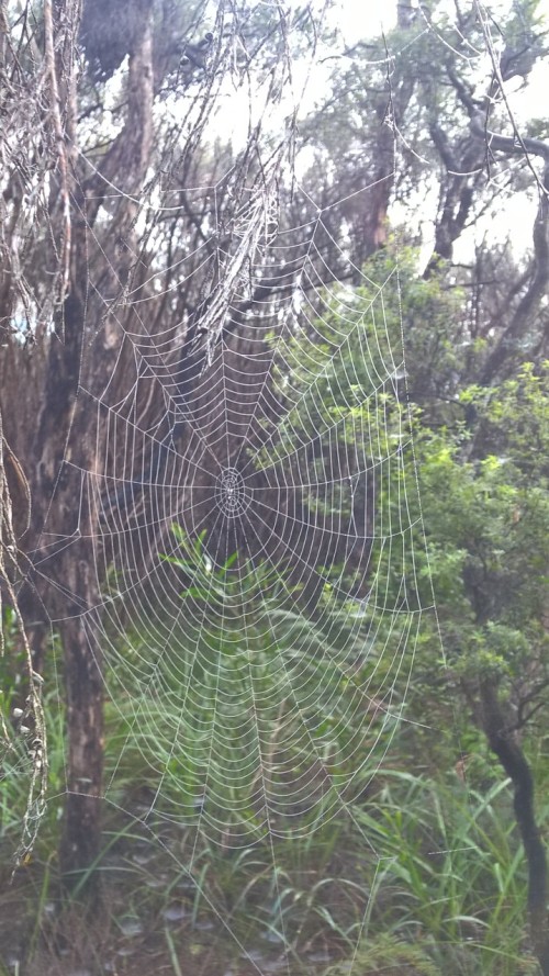
One of the many photos I took of dew covered webs
I finally learned why they call the tall rubber boots gumboots here. The term originated from the boots the gumdiggers wore when searching for kauri gum in the wet, muddy swamps where they dug for it. Gumboots or “gummies” as many refer to them here are still a very popular choice in footwear for New Zealanders, from fishermen to farmers.

Gumboots
After that we were treated to a hot lunch cooked just for our tour group at a little café along the highway before getting to Cape Reinga. During the last stretch of the drive to the top, our driver and guide, Daniel, told us the Maori legend and the history of why the natives considered this such a sacred place.
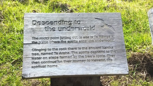
A summary of the significance of Cape Reinga to the Maori
Once there, we could sense what an incredible spot this was. There really seemed to be something special about standing at the lighthouse at the northernmost point of the country, not only because of the beauty, but because you could feel invisible energy of incomprehensible significance
Cape Reinga
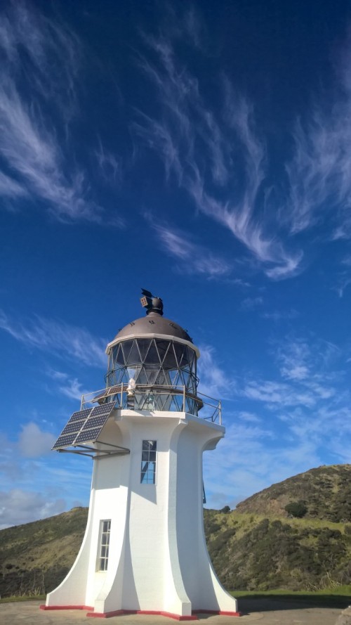
Lighthouse at Cape Reinga
Besides the Maori legend of it being the pathway of the spirits, it is literally where the Tasman Sea and Pacific Ocean meet, and you could see the swirling waters where they came together just below the lighthouse.

Lighthouse with swirling waters to the left.

Turbulence where Pacific and Tasman Sea meet
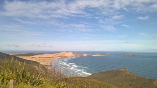
With no place to go but back the way we’d come, we drove down and turned to Te Paki stream. The road ended and we kept driving right into the stream. Daniel engaged the 4WD and drove us down the center of the flow of water.

On our way to the dunes, see them on the horizon.

Te Paki stream with dunes in the distance

Te Paki stream, our access point to 90 mile beach
We followed it until we were amidst the giant sand dunes. Once we were able to stop on solid ground. We had the opportunity to hop out and grab a boogie board to ride a dune. Daniel gave us a quick lesson and then sent us on our way to climb the massive pile of sand. It really was quite a climb and just like staring down a ski hill, it looked much steeper staring at the bottom knowing you were about ready to release yourself to the force of gravity.

Dune riding. You can barely make out the people at the top getting ready to slide down.
I was the first to plant myself prostrate on the board, face first down the mountain of sand. What a rush! I went zipping down, dragging my toes behind me because I was frightened of going too fast and those were supposed to be my brakes. It really only slowed me down a little and somehow I managed to stay on the board for the entire ride even when I went bouncing over some tire tracks near the bottom and got a face full of sand. What a blast! I grabbed my board and began the climb to have another go. Paul and I each got two runs before it was time for the tour to move on. Here’s a couple of videos so you can get an idea of the speed. Paul dune riding video. Deb dune riding video.
Through the stream we went, all the way to the beach where it flowed into the ocean. Ninety mile beach, it’s called and is actually sixty five miles long. The name, Daniel explained, was from when livestock traders drove their herds along the beach. They estimated that they drove the livestock thirty miles a day and it took them three days to make it to the other end of the beach. The vast expanse of sand and surf stretched as far as we could see, to where it met the sky.

Dune Rider bus under sweeping skyscape

90 mile beach
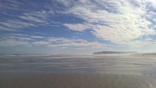
90 mile beach. The tiny black dot on the right is a vehicle in the distance.
We made one stop where we got to step out on to the endless beach. I attempted to capture the scene in photos but they just don’t convey the magnitude of such a place. On we went following the highway of sand with the waves thundering in over and over again for miles and miles. When we reached the exit ramp, we had traveled about forty miles down the sand. It was such an incredible tour enhanced by an brilliant day of sunshine and dramatic clouds contrasting against a blue sky backdrop. The grand finale was an intense and enduring sunset sweeping the skyscape off the balcony of the house.

Sunset at 90 mile beach, Ahipara

Same sunset, several minutes later.
The forecast indicated rain for the next couple of days and we didn’t really care since we could enjoy the sights and sounds of the beach right from the house. That is exactly what we did for two days of rain. Then it subsided and the following days were only partly cloudy. We had ample time sit back both on the deck and during long strolls on the beach.

Sand patterns on 90 mile beach

Deb getting her toes wet on 90 mile beach

low profile on 90 mile beach
Too soon the week drew to a close and it was time to move on. We prepared to depart the incredible place on ninety mile beach, so grateful for the time we’d enjoyed there.

After Paul’s folks departed, we remained in Nelson for another week savoring the sun. There were several more walks down the hill to and hacky sack sessions on Tahunanui beach when we weren’t just relaxing with the view over the bay.

Days track to Tahunanui beach

Garden art at “a room with a view”

View of Tasman Bay from our apartment “a room with a view”
On Sunday, we parked Zed and boarded a small plane for Auckland. The next five weeks we planned to spend seeing some sights on the North Island. Once we picked up our rental car, the first destination was the Coromandel Peninsula. From Auckland it was about a two hour drive. Fortunately our timing meant we would be driving out of Auckland when the majority of the traffic was heading back into Auckland after the weekend. It was nice to be able to avoid the traffic jams that regularly plague the Auckland area. Soon we moved beyond the edge of the metropolitan area watching rolling green hills and lots of dairy cows go by, like we’ve seen almost everywhere we’ve been in the country so far. It was not early enough in the day to make it all the way to Coromandel Town before dark, plus we decided to stock up on groceries at the large supermarket in Thames which meant we drove up the coast of the peninsula in the dark. From what we could tell from the headlights and moon the scenery promised to be stunning in the daylight. The road was narrow and winding, which was not a surprise. We easily found our apartment called “the treehouse” in Coromandel Town and quickly settled in.

The next morning we met Dom, a local who happened to be staying in a nearby cabin and working for the owners of the property where we were staying. He immediately mentioned New Chums beach as a must see while we were on the peninsula. Since the sun was out, and it was still the weekend, we decided to check it out. Thankfully, he had explained just how to get to the beach and told us it would involve crossing a stream that could vary considerably in width and depth. We found the sign post and the instructions a bit confusing and the track rather difficult to find which made us even more thankful for Dom’s information about how to access the famous beach.

The stream we had to cross

Navigating the boulders on Whangapoua beach to the track over to New Chums beach
We unintentionally arrived near low tide and we were so grateful that it worked out that way because we only had to wade across a small shallow water channel on Whangapoua beach. From there we made our way across the boulders scattered along the edge before finding a very steep track up and over a little neck of land that separated Whangapoua beach and New Chums beach. The light sand was so sparkly and seashells were scattered everywhere. As you walked the sand squeaked underfoot. It reminded me of walking on snow on an extremely cold winter’s day and hearing it squeak on my boots, except that it was not cold at all and I was barefoot. It was so fascinating. There was only one other lady at the beach. The leisurely walk down the beach and back was delightful.
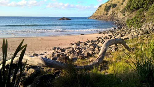
New Chums beach

New Chums Beach

New Chums Beach

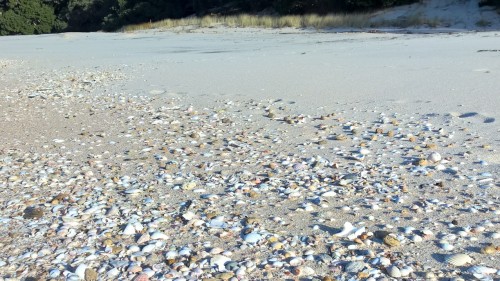
sparkly sand and seashells at New Chums Beach
The following day was cloudy, but not rainy, so after Paul finished work we walked into town to have a look around and have lunch. We stopped in at Umu’s café, another of Dom’s recommendations for lunch and tea, and it was awesome. It didn’t take long to see town, as it’s a rather small community. We were glad to be outside and of course found time for hacky sack in the park before going back to the treehouse. Then the rain came, continued all night long, and through the next day and night too. By that time, we both had a severe case of cabin fever as we’d chosen to stay inside and dry. There was enough space to hacky sack inside, which we did a lot. We only kicked it out through the open window a couple of times. Yes, it’s odd that the windows would be open during the rain, but they were designed such that the rain did not come in and the clouds and rain were actually making the temperatures rather mild for this time of year we were told. Besides hacky sack, we skyped, we read, we watched TV, we surfed the internet, I colored, Paul worked, we sat, we ate, but not necessarily in that order.

Paul retrieving the hacky sack that apparently was as eager to get outside as we were.
The clouds still hung low on the third day when Paul finished work. Despite the threat of more showers, we headed out for some fresh air. We prepared to get wet and set out to do the Harray track. We turned off the main road and walked just a short distance before coming to a tree with a large arrow on a sign saying “Harray track please cross here” next to a creek that after 2 days of rain was rather swollen. You could see a line of stones across the river, but the water flowing well over them and cascading rapidly down the other side.

The beginning of the Harray Track, as far as we made it.
We didn’t stand too long considering our options before turning and going back to the road. We found another short loop track and walked that before walking into town for tea at Umu’s café. By the time we finished, the clouds were breaking up and we could see patches of blue sky. We found another track that lead to a lookout over Coromandel Town on one side and the ocean on the other.

Coromandel Town from the lookout
The ocean from the lookout
We continued on and made a loop of a few miles that passed by the other end of Harray’s track then around the wharf and back into town. It was simply wonderful to be outside.
We were treated to another dry day the next day and took the opportunity to check out the Driving Creek Railway at the recommendation of one of our hosts. It was only a few miles up the road, so we had a nice walk in addition to getting to ride the little train up to the “Eyefull Tower.” It was an awesome ride up the rails that zig zagged up the hillside, complete with a double decker bridge and tunnels. The entire operation was the vision of one man, Barry Brickell, and he did most of the work himself to build not only the railway but the trains as well. The whole thing was quite a unique experience. Our train operator had worked for many years for the owner and could point out many of the retaining walls he’d built from glass bottles. These, and the artistic pottery that dotted the route were my favorite parts of the experience. Interestingly, the entire railway project started as a way to get the clay from the hill down to Barry’s workshop so he could pursue his passion of sculpting pottery. The railway morphed into a project that has become a huge tourist attraction which was well worth the visit.
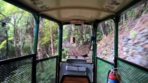
riding the Driving Creek Railway
With the forecast calling for more rain, we wanted to see as much as we could during the clear weather so after the train ride we walked back to the house for the car. We drove down to the carpark at Long Bay. Our host told us there was a walk over to Tuck’s Bay and along the way a giant ancient Kauri tree. We’d heard a bit about these trees and wanted to check it out.

“baby” kauri trees
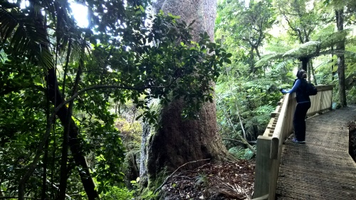
huge kauri tree estimated to be 1200 years old

Ancient Kauri tree
Wow! This one was massive and apparently not the biggest one here on the North Island of New Zealand. Tuck’s Bay was lovely and a perfect spot for some hacky sack on the green grass.

Tuck’s Bay
The rain came again, just as forecasted, and we watched from inside just as expected. I took a few minutes to bake an apple crumble in between the other inside activities already mentioned. In between rain showers we enjoyed watching the adorable resident fantail and quail.

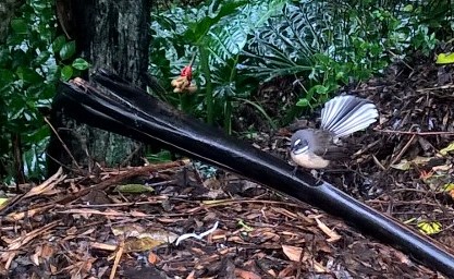
Fantail

Quail
That brought us to the weekend and there were still a couple of places we wanted to see before leaving the peninsula, but as we got ready to head out for the day, the rain came again. We paused, considered and decided we would go anyway as we likely would not have another opportunity. The locals casually advised us to drive the 309 road over to the east coast. Our destination was Cathedral Cove. The 309 road, which we expected to be at least a two lane highway, was, well, mostly two lanes but gravel for much of the way. Soon after we crossed the top and began descending to the opposite coast, the sun came out and blue skies welcomed us at the carpark for the walk to Cathedral Cove. We were in disbelief, simply astounded at how crystal clear the day turned out to be.

View from the carpark at Cathedral Cove
We walked to Cathedral Cove, strolled along the beach with plenty of time to take pictures and then paused to take in the scenery at both Stingray Bay and Gemstone Bay on our way back to the car.

View from carpark at Cathedral Cove
Rather than drive the 309 again, we chose to take another route, one we’d driven earlier in the week. This let us see a little more of the east coast and as we turned west, we faced a band of obviously heavy showers directly in our path. When we pulled off next to the ocean to take a few pictures, we both decided it would be much more pleasant to watch the rain fall there than while trying to drive the curvy narrow road.

In a matter of ten minutes the black cloud moved over us, pelted the car with water and moved past revealing blue sky with the sun illuminating a brilliant rainbow against the backside of the black curtain. It was a wonderful day spent in unexpected sunshine. The next day more clouds and drizzle arrived, we waited for a clearing and walked into town in the afternoon; we didn’t quite make it before another round of drizzle blew over. The next day was much the same, though after we got rained on, we kept walking and did get a few hours of clear skies to walk up to the lookout again.
Walking along Wharf Road in Coromandel Town

We tried to remember those lovely moments in the fresh outdoor air as we spent yet another day inside when the downpours returned. Cloudy skies remained the following day but thankfully it was not raining. We went out for a long walk before getting to spend some time on the deck at the treehouse for the first time. We walked into town for dinner, arriving at the restaurant where we intended to eat an hour before they began serving dinner. So, we kept walking and discovered that the Umu’s was open for dinner, so we looked no further. There was no rain, no clouds and no street lights on our walk back to the treehouse. Three ingredients that combined for the most brilliant night sky. Trying to navigate the path in the dark staring up at the milky way with our mouths agape caused us to bump into each other more than once. The clear skies resulted in much colder temperatures overnight, but the next morning the sun punched through that clear sky and lit up the tree ferns, flowering bushes, and palm trees against an intense blue sky. We were eager to get outside after Paul finished work. We knew we wanted to find a beach and we decided to head for New Chums beach again, aware that the tide would be high at 4pm and we may not be able to get over the river to the track.

The channel close to high tide, would have been well over 6 ft deep in the center.
We arrived at about 2pm and immediately could see that Whangapoua beach looked much different than the last time we were there. The channel was deeper but not over our knees, so we crossed, took a few more steps then paused to look at each other. We realized we were thinking the same thing. If the water channel was already about as deep as we wanted to cross and the tide was still coming in it would be considerably deeper by the time we walked to New Chums beach and back again. Plus looking ahead around the beach where we’d pick up track to New Chums we could see the water was already covering many of the rocks. It didn’t take us long to decide to just stay on Whangapoua beach. The water channel deepened and widened rather quickly and one couple coming back from New Chums nearly had to swim across. We breathed a sigh of relief that we’d chosen to simply stay put. The sun stayed out all afternoon. We strolled along the beach and back again. We sat and had a snack and played hacky sack and lingered until our shadows fell long across the sand.

Sunny day at Whangapoua Beach

This calls for a happy handstand

and a happy dance!
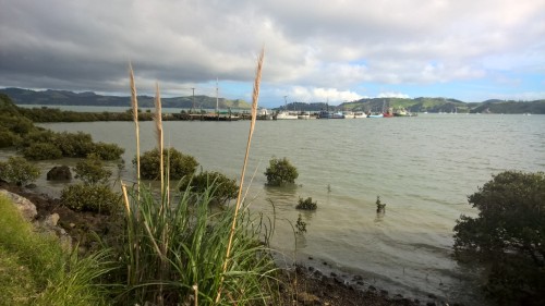
That night was the last in the treehouse and the end of our stay on the Coromandel peninsula. When we departed we got to drive along the coast into Thames in the daylight. It was a perfect day to take in the spectacular scenery looking across the bay toward Auckland, where we were headed.


This gallery contains 98 photos.
We were privileged to welcome Paul’s parents, Jack and Janette, for a twelve day visit. After much discussion and lots of planning we sketched out an itinerary to show them some of our favorite places during their brief time … Continue reading

This gallery contains 2 photos.
We delayed our departure from the Shed as long as we could to still make it to Bluff before dark. The morning scene was thick with apprehension of the inevitable moment of parting. David came over to the workshop and … Continue reading

This gallery contains 4 photos.
Departing Renwick just after breakfast, we drove south along the east coast under gray skies toward our next destination, the Shed and Breakfast. The journey, we estimated, would take nearly seven hours and we wanted to arrive before dark. We … Continue reading

This gallery contains 42 photos.
So both of us will admit up front that before we even arrived here in Renwick, we’d already begun to sense our disappointment. I mean, how could we leave Kaikoura, where we could see and hear the ocean and walk … Continue reading

This gallery contains 54 photos.
We drove north on highway 1 on a cool, wet morning through the outskirts of Christchurch. Now here we are back in Kaikoura. We were here for a few days back in late July and early August of last year when we … Continue reading


")
")
")
")
")
")
")
")
")
")
")
")
")
")
")
")
")
")
")
")
")
")
")
")
")
")
")
")
")
")
")
")
")
")
")
")
")
")
")
")
")

")
")
")
")
")
")
")
")
")
")


")


")
")
")


")
")
")

")
")
")
")
")
")
")
")
")

")
")
")
")
")
")
")
")
")


")
")
")
")
")
")
")
")
")
")
")
")
")
")
")
")
")
")
")
")
")
")
")
")
")
")
")
")
")
")
")
")
")
")
")
")
")
")
")
")
")
")
")
")
")
")
")
")
")
")
")
")
")


")
")
")
")
")
")
")


")


")

")
")

")
")

")
")

")
")
")
")
")
")
")
")
")
")
")
")
")
")
")
")
")
")
")
")
")
")
")
")
")
")
")
")
")

")
")
")
")


")
")

")
")
")
")
")
")
")
")
")
")
")
")


")
")

")
")
")
")
")
")
")
")
")


")
")
")


")
")
")
")
")

")


")
")
")


")

")
")
")
")
")
")
")
")
")

")
")


")

")
")
")
")
")
")
")
")
")
")
")

")
")
")
")
")
")
")

")

")
")
")
")
")
")
")
")
")
")
")
")


")
")
")
")
")
")
")
")
")
")
")
")
")
")
")
")
")
")
")
")
")
")
")
")
")
")
")
")
")
")
")
")
")
")
")
")
")


")
")
")
")
")
")
")
")
")
")
")
")
")
")
")
")
")
")
")
")
")
")
")
")
")
")
")

")
")
")
")
")
")
")
")
")
")
")
")
")
")
")


")

")
")
")
")
")
")
")
")
")
")
")

")
")
")
")
")
")
")
")
")
")
")
")
")
")
")
")
")
")
")


")
")
")
")
")
")
")
")
")
")
")
")
")
")
")
")
")
")
")
")
")
")
")
")
")
")
")
")
")
")
")
")
")
")
")
")
")
")
")
")
")
")
")
")
")
")
")
")
")
")
")
")
")
")
")
")
")
")
")
")
")
")
")
")
")
")
")
")
")
")
")
")


")
")
")
")
")
")
")
")
")
")
")
")
")
")
")
")
")

")
")
")
")
")
")
")
")
")
")
")
")
")
")
")
")
")
")
")
")
")
")
")
")
")
")
")
")
")
")
")
")
")
")
")

")
")
")
")
")
")
")
")
")
")
")
")
")
")
")
")
")
")
")
")
")
")
")
")
")
")
")
")
")
")
")
")
")
")
")
")
")
")
")

")
")
")
")
")
")
")
")
")
")
")
")
")
")
")
")
")
")
")
")
")
")
")
")
")
")
")
")
")
")
")
")
")
")
")
")
")
")
")
")
")
")
")
")
")
")
")
")
")
")
")
")
")
")
")
")
")
")
")
")
")
")
")
")
")
")
")
")
")
")

")
")
")
")
")

")
")
")
")
")
")
")
")
")
")
")
")
")
")
")
")
")
")
")
")

")
")
")
")
")
")
")
")
")
")
")
")
")

")
")
")

")
")
")
")
")

")
")
")
")
")
")
")
")
")
")
")
")
")
")
")
")
")
")
")
")
")
")
")
")
")
")
")

")


")
")
")
")
")


")

")
")

")


")


")


")
")
")
")


")


")
")
")
")
")
")


")


")
